The Messabi trail is unlike any other bike trail I've been on. It's beautiful with abundant wild flowers, a little bit insane in its ambition, and a credit to local champions and state and federal government programs that support low income rural America. It has been pieced together over 30 years from smaller local trails and extensive new trail construction in severe terrain and severe climate -- requiring painstaking negotiations with the lawyers of the wealthy investors (ex: Astors!) who purchased mineral rights in the 1920s and 1930s. Last year the
MN Star Tribune described the trail.
We did the entire trail between Ely and Grand Rapids. It's marketed to be ridden in the other direction, but doing it in reverse shortened our drive home. We parked at the trailhead in Grand Rapids and took the excellent shuttle to Ely. There's a modest altitude drop from Ely to Grand Rapids, but traveling east to west as we did does run into the usual westerly winds. We were fortunate to have excellent weather.
Around the middle of the trail you cross the
Laurentian Divide. To the west water flows to the Mississippi, to the east it flows to Hudson Bay (there's some complexity with the St Lawrence divide where water flows to Superior and the St Lawrence river but I didn't sort that out).
This is not one of those flat and straight rail trails we know and love. This trail has extraordinary bridges over wetland a mining waters but it often follows the terrain. Terrain that includes many punchy climbs and descents. I have never shifted my old touring bike triple chainring as much as I did during our trip!
The trail is beautiful and often lovely to ride, but unless you have an eBike there is real work involved. We did roughly 70 miles each day with panniers and it felt more like a 90 mile road ride. Work is continuing on remaining segments. Severe weather washed out a segment near Giants Ridge, on a weekend we were able to duck under the barriers and (easily) ride through -- there was no obvious alternative! One unfinished section of the trail requires a few miles on no-shoulder but quiet road. There are gravel segments. Expect debris on the trail; the weather can be harsh at times.
If I were to do it again I'd either do it over 3-4 days or do it in segments and spend more time visiting the communities and admiring the scenery. On the other hand, given the time we had, two days was excellent.
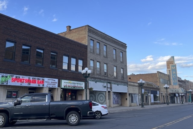
The trail is both an adventure and an education. You can see many of the issues that are common across rural America -- people who established roots in places that no longer have an economic foundation. You pass through extensive open pit mines now being replaced by nature, sometimes on a narrow ridge between vast pits, sometimes between and over piles of removed rock. This is all more engaging and lovely than you might think.
Some lessons and tips from our experience.
- Order the paper trail map. I am surprised they don't provide a PDF version of this. If you don't order in advance they are available at trailheads.
- There are some long stretches, especially between Ely and Virginia, without water access. We needed a LOT of water. Two big water bottles were not enough for some stretches. I'd recommend an additional bottle.
- You need to use the Ride With GPS segments they provide. The trail map is not sufficient for navigation given limited signage and ongoing trail construction.
- You want a bike with a wide gear range and at least 32 mm tires for the gravel stretches.
- In several towns there is only the local pub to get water or food from. This area has been losing population, especially young people, for generations. Some towns have lost local groceries and local restaurants (other than the pub).
- I always had mobile coverage. That's good because this is a remote and rugged area and on several segments we saw very few people.
- Signage is limited. I don't know if vandals are removing them or if more sign work is planned for a later stage.
- Periodically check the satellite view to see what's outside the trail. One of the amazing things about this adventure is seeing nature reclaiming the old mines.
- Try to spend some money in the local communities. They need it. There is usually at least a pub, if you don't want a beer gets some fluids or snacks or a meal.
 |
Paper trail map: You want this. |
 |
| Trailhead arches display town name |
 |
| Historical exhibits along trail |
 |
Town MN McKinley / Great War monument
|
|
 |
| Pontoon bridges are LOUD but spectacular wetland view |
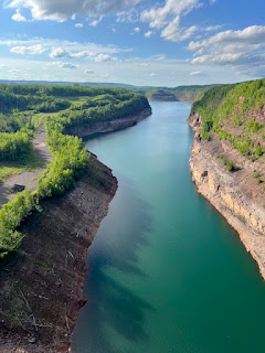 |
| MN highest bridge east of Virginia - this is a pit mine |
 |
| Virginia has steam vents for a system that once heated the town |
 |
| Saywer is one of many state funded parks and monuments in Virginia |
 |
| WPA fountain later restored. A testimony to government really |
 |
| Trailside exhibit, one of last of underground mines |
 |
| Downtown Virginia, much is gone but some new gems |
 |
| All the brown is open pit mines - mostly invisible from the trail |